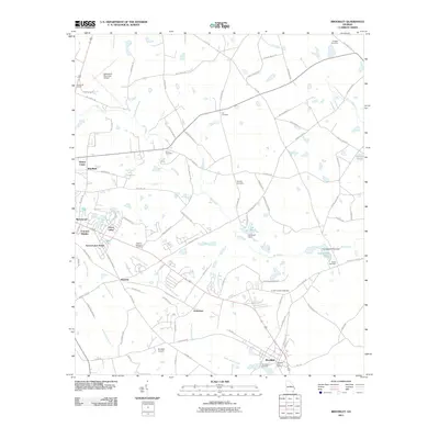
2011 Map of Brooklet
USGS Topo · Published 2011About this map
Brooklet anchors the southern portion of this Bulloch County landscape, which is defined by the branching waterways of Upper Black Creek and Mill Creek. By the early 21st century, the area surrounding the Statesboro Municipal Airport in the northwest and the newer residential developments like Colonial Heights and Merrywood reflect the steady growth of the region. Despite this modernization, the map preserves a dense network of family-named landmarks and rural burial grounds, including the Corinth-Leefield Cemetery and Lee Cemetery. The terrain is marked by numerous small water bodies and dams such as Youngblood Pond Dam and Lee Pond Dam, signaling a landscape historically managed for agricultural and recreational use. The presence of both the municipal airport and the smaller Brooklet Airpark highlights the area's significance for regional aviation and local connectivity.
Find a feature on this map
91 named features on this map. Tap any name to fly to it.
Don’t see what you’re looking for? This feature index may not catch every label — zoom into the map to look around manually.
Map Details
Editions of this 2011 Brooklet Map
This is the sole edition of this map. No revisions or reprints were ever made.
Other maps of this area

1918 · Oliver
USGS Topo · 1:62,500

1920 · Statesboro
USGS Topo · 1:62,500

1920 · Oliver
USGS Topo · 1:62,500

1921 · Brooklet
USGS Topo · 1:62,500

1921 · Rocky Ford
USGS Topo · 1:62,500

1943 · Brooklet
USGS Topo · 1:62,500

1943 · Rocky Ford
USGS Topo · 1:62,500

1943 · Millen
USGS Topo · 1:125,000

1943 · Statesboro
USGS Topo · 1:62,500

1943 · Oliver
USGS Topo · 1:62,500