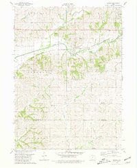
1980 Map of Brooks
USGS Topo · Published 1981About this map
The East Nodaway River carves a path through this section of southwestern Iowa, where the Burlington Northern railroad serves as the primary corridor for commerce and travel. The settlement of Brooks stands as a focal point in Nodaway township, while the small community of Iveyville appears further south along the divide between the West Fork and Rose Branch. This landscape is characterized by its agricultural roots, evidenced by the numerous country cemeteries like Methodist Grove Cem and Prairie Rose Cem that anchor the local genealogy. Unusual water naming conventions are found here, specifically the headwaters of the One Hundred and Two River, which flows southward toward the Adams and Taylor county line. Aviation infrastructure is surprisingly present for a rural area, with both the Corning Muni Airport and the smaller Bycroft Landing Field located on the eastern and southern edges of the quadrangle.
Find a feature on this map
25 named features on this map. Tap any name to fly to it.
Don’t see what you’re looking for? This feature index may not catch every label — zoom into the map to look around manually.
Map Details
Editions of this 1980 Brooks Map
This is the sole edition of this map. No revisions or reprints were ever made.
Other maps of this area

1954 · Omaha
USGS Topo · 1:250,000

1955 · Nebraska City
USGS Topo · 1:250,000

1957 · Nebraska City
USGS Topo · 1:250,000

1957 · Omaha
USGS Topo · 1:250,000

1958 · Omaha
USGS Topo · 1:250,000

1958 · Nebraska City
USGS Topo · 1:250,000

1980 · Corning South
USGS Topo · 1:24,000

1980 · Gravity
USGS Topo · 1:24,000

1980 · Guss
USGS Topo · 1:24,000

1980 · Corning North
USGS Topo · 1:24,000