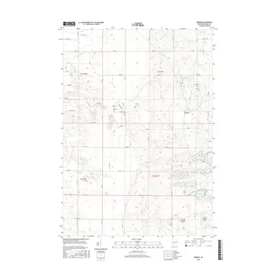
2016 Map of Brooks
USGS Topo · Published 2016About this map
Brooks is situated at the heart of this central Wisconsin landscape, characterized by a high density of small kettle lakes and wetlands in Adams County. The settlement pattern reflects a mix of traditional township grids and more recent residential developments centered around recreation and private aviation, as evidenced by the Clearwater Aero Estates Airport and Bulldog Ranch Airport. The topography is defined by the winding course of Neenah Cr and Peppermill Cr, which feed into several larger water bodies including McGinnis Lake, Parker Lake, and Deep Lake. This 2016 survey illustrates the balance between agricultural land and preserved natural spaces, with numerous residential drives like Evergreen Dr and Fawn Ave branching out from older county thoroughfares. These small lakes, such as Beaver Pond 1 and Goose Lake, serve as focal points for the local geography, surrounded by the shifting elevations of the driftless region.
Find a feature on this map
72 named features on this map. Tap any name to fly to it.
Don’t see what you’re looking for? This feature index may not catch every label — zoom into the map to look around manually.
Map Details
Editions of this 2016 Brooks Map
This is the sole edition of this map. No revisions or reprints were ever made.
Other maps of this area

1901 · The Dells
USGS Topo · 1:62,500

1902 · Briggsville
USGS Topo · 1:62,500

1957 · Wisconsin Dells
USGS Topo · 1:62,500

1957 · Madison
USGS Topo · 1:250,000

1958 · Briggsville
USGS Topo · 1:62,500

1960 · Madison
USGS Topo · 1:250,000

1961 · Oxford
USGS Topo · 1:62,500

1961 · Adams
USGS Topo · 1:62,500
1975 · Wisconsin Dells NE
USGS Topo · 1:24,000
1975 · Big Spring
USGS Topo · 1:24,000