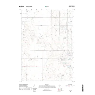
2018 Map of Brooks
USGS Topo · Published 2018About this map
The unincorporated community of Brooks serves as the primary settlement in this Adams County landscape, situated near the headwaters of Neenah Cr. The area is characterized by a high density of small glacial lakes and drainage systems, including the complex around Goose Lake, McDougall Lake, and Deep Lake. These water bodies are connected by minor streams such as Peppermill Cr, which winds through the southern portion of the sheet. Modern transportation and recreation are represented by specialized aviation facilities, notably the Clearwater-Aero-Estates Airport and the Bulldog Ranch Airport located in the southeastern quadrant. The map also reveals a localized grid of rural residential roads, such as Edgewood Dr and Fawn Ave, that weave between the kettles and depressions of the surrounding terrain near larger bodies of water like Parker Lake.
Find a feature on this map
44 named features on this map. Tap any name to fly to it.
Don’t see what you’re looking for? This feature index may not catch every label — zoom into the map to look around manually.
Map Details
Editions of this 2018 Brooks Map
This is the sole edition of this map. No revisions or reprints were ever made.
Other maps of this area

1901 · The Dells
USGS Topo · 1:62,500

1902 · Briggsville
USGS Topo · 1:62,500

1957 · Wisconsin Dells
USGS Topo · 1:62,500

1957 · Madison
USGS Topo · 1:250,000

1958 · Briggsville
USGS Topo · 1:62,500

1960 · Madison
USGS Topo · 1:250,000

1961 · Oxford
USGS Topo · 1:62,500

1961 · Adams
USGS Topo · 1:62,500
1975 · Wisconsin Dells NE
USGS Topo · 1:24,000
1975 · Big Spring
USGS Topo · 1:24,000