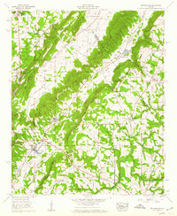
1958 Map of Brooksville
USGS Topo · Published 1960About this map
Brooksville and Strawberry anchor this 1950s landscape where the ridges of Sand Mountain meet the dramatic folds of the Tennessee Valley. This survey captures a moment of established rural life in Blount Co and Marshall Co, marked by an extensive network of country churches and family burial grounds like Pleasant Hill Ch and Alldredge Cem. The map reveals historical land divisions, most notably the Old Cherokee Boundary and the modern The Heart Of Dixie Highway. Water dominates the local economy and geography, from the Locust Fork Warrior River in the south to the Minnow hatchery and Guntersville Caverns in the north. The terrain is defined by distinctive gaps, such as Hobson Gap and Gilbreth Gap, which have historically funneled travel through the steep ridges of Tower Ridge and Back Valley.
Find a feature on this map
65 named features on this map. Tap any name to fly to it.
Don’t see what you’re looking for? This feature index may not catch every label — zoom into the map to look around manually.
Map Details
Editions of this 1958 Brooksville Map
3 editions found
Other maps of this area

1885 · Gadsden
USGS Topo · 1:125,000

1888 · Cullman
USGS Topo · 1:125,000

1888 · Gadsden
USGS Topo · 1:125,000

1892 · Cullman
USGS Topo · 1:125,000

1892 · Gadsden
USGS Topo · 1:125,000

1895 · Gadsden
USGS Topo · 1:125,000

1903 · Gadsden
USGS Topo · 1:125,000

1936 · Guntersville
USGS Topo · 1:24,000

1936 · Hulaco
USGS Topo · 1:24,000

1936 · Arab
USGS Topo · 1:24,000