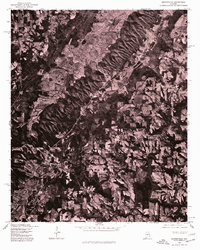
1975 Map of Brooksville
USGS Topo · Published 1977About this map
Brooksville and the surrounding Blount County landscape appear in high-contrast detail in this 1975 orthophotograph, produced by the Geological Survey in cooperation with the Soil Conservation Service. The imagery reveals the complex relationship between the agricultural valley floors and the densely wooded ridges characteristic of this part of Alabama. Unlike a traditional line-and-symbol map, this aerial perspective allows for the direct observation of land-use patterns, from the organized grid of farm plots near Nixon Chapel to the winding country roads that connect these small rural communities. The sharp distinction between the light-toned cleared fields and the dark shadows of the topographic relief provides a clear record of the region's mid-1970s rural development and natural forest cover.
Find a feature on this map
2 named features on this map. Tap any name to fly to it.
Don’t see what you’re looking for? This feature index may not catch every label — zoom into the map to look around manually.
Map Details
Editions of this 1975 Brooksville Map
2 editions found
Other maps of this area

1885 · Gadsden
USGS Topo · 1:125,000

1888 · Cullman
USGS Topo · 1:125,000

1888 · Gadsden
USGS Topo · 1:125,000

1892 · Cullman
USGS Topo · 1:125,000

1892 · Gadsden
USGS Topo · 1:125,000

1895 · Gadsden
USGS Topo · 1:125,000

1903 · Gadsden
USGS Topo · 1:125,000

1936 · Guntersville
USGS Topo · 1:24,000

1936 · Hulaco
USGS Topo · 1:24,000

1936 · Arab
USGS Topo · 1:24,000