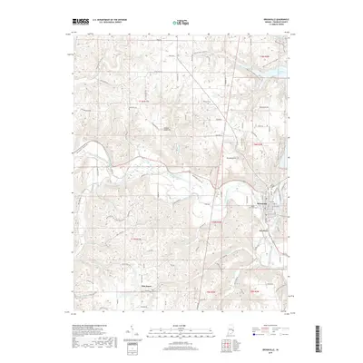
2019 Map of Brookville
USGS Topo · Published 2019About this map
Brookville serves as the focal point of this landscape, situated at the confluence of the Whitewater River and its East Fork. The town's historical depth is evident in the numerous burial grounds surrounding it, including Saint Michaels Cem and Maple Grove Cem. To the north, the massive Brookville Lake dominates the valley, while the surrounding hills are marked by distinct landmarks like Boundary Hill and Yellow Bank Hill. The rural reaches are dotted with smaller settlements like Stavetown and Oak Forest, connected by a network of winding roads such as McGuire Ridge Rd and Yellow Bank Rd. Genealogists will find particular value in the scattered family and church plots, from the McKenzie Cem in the northwest to the Wolf Creek Cem in the south, preserving the names of the families who settled this part of Franklin County.
Find a feature on this map
102 named features on this map. Tap any name to fly to it.
Don’t see what you’re looking for? This feature index may not catch every label — zoom into the map to look around manually.
Map Details
Editions of this 2019 Brookville Map
This is the sole edition of this map. No revisions or reprints were ever made.
Other maps of this area

1915 · College Corner
USGS Topo · 1:48,000

1915 · Harrison
USGS Topo · 1:48,000

1918 · College Corner
USGS Topo · 1:62,500

1946 · Batesville
USGS Topo · 1:24,000

1948 · Fairfield
USGS Topo · 1:24,000

1953 · Cincinnati
USGS Topo · 1:250,000

1955 · Mount Carmel
USGS Topo · 1:24,000
1955 · Cedar Grove
USGS Topo · 1:24,000

1956 · Everton
USGS Topo · 1:24,000

1956 · Alpine
USGS Topo · 1:24,000