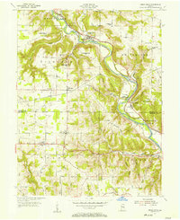
1955 Map of Cedar Grove
USGS Topo · Published 1957About this map
Whitewater River valleys and the sharp topographic rises of southeastern Indiana define this mid-century landscape. The New York Central Line parallels the river, anchoring the settlements of Cedar Grove, New Trenton, and the landing at Longnecker. These riverfront villages contrast with the upland farming communities of Saint Leon and South Gate, which are situated on the higher plateaus above the river's dissecting tributaries like Blue Creek and Ramsey Creek.
Find a feature on this map
49 named features on this map. Tap any name to fly to it.
Don’t see what you’re looking for? This feature index may not catch every label — zoom into the map to look around manually.
Map Details
Editions of this 1955 Cedar Grove Map
This is the sole edition of this map. No revisions or reprints were ever made.
Other maps of this area

1915 · Lawrenceburg
USGS Topo · 1:48,000

1915 · Harrison
USGS Topo · 1:48,000

1928 · Lawrenceburg
USGS Topo · 1:62,500

1932 · Lawrenceburg
USGS Topo · 1:62,500

1943 · Hooven
USGS Topo · 1:24,000

1943 · Guilford
USGS Topo · 1:24,000

1953 · Guilford
USGS Topo · 1:24,000

1953 · Cincinnati
USGS Topo · 1:250,000
1954 · Hooven
USGS Topo · 1:24,000

1955 · Harrison
USGS Topo · 1:24,000