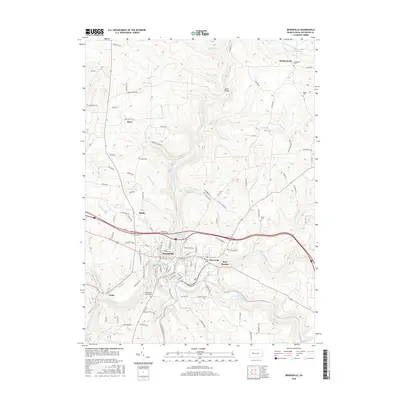
2016 Map of Brookville
USGS Topo · Published 2016About this map
Brookville serves as the central hub of this Jefferson County landscape, where the confluence of North Fork Redbank Creek and Sandy Lick Creek forms the main stem of Redbank Creek. The town's grid, including streets like S Main St and Western Ave, is tightly contained by the surrounding plateau topography. Outside the borough, smaller settlements and crossroads such as Port Barnett and Pinecreek line the eastern transport corridors, while Alaska and Howe sit to the north. Local history and genealogy are anchored by several upland burial sites, including Saint Marys Cemeteries south of town, and the more remote Moorhead Cem and Riggs Cem near the northern boundary. The mapping of numerous runs like Pekin Run and Sugarcamp Run illustrates the deeply dissected nature of this creek-carved region.
Find a feature on this map
102 named features on this map. Tap any name to fly to it.
Don’t see what you’re looking for? This feature index may not catch every label — zoom into the map to look around manually.
Map Details
Editions of this 2016 Brookville Map
This is the sole edition of this map. No revisions or reprints were ever made.
Other maps of this area

1918 · Loleta
USGS Topo · 1:62,500

1922 · Du Bois
USGS Topo · 1:62,500

1924 · Du Bois
USGS Topo · 1:62,500

1924 · Brookville
USGS Topo · 1:62,500

1926 · Brookville
USGS Topo · 1:62,500

1936 · Marienville
USGS Topo · 1:48,000

1940 · Hallton
USGS Topo · 1:48,000

1941 · Marienville
USGS Topo · 1:62,500

1943 · Hallton
USGS Topo · 1:62,500

1944 · Du Bois
USGS Topo · 1:62,500
Featured Places
- Brookville, PA
- Warsaw Township, PA
- Knox Township, PA
- Pine Creek Township, PA
- Richardsville, Warsaw Township