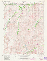
1957 Map of Brookville SW
USGS Topo · Published 1980About this map
Mulberry Creek and Saline Creek meander through this central Kansas landscape, defining a region of drainage basins and township divisions along the border of Lincoln and Ellsworth counties. The southern edge of the map is dominated by the industrial and military presence of the Union Pacific railroad and the northern reaches of the Smoky Hill Air Force Range. The small settlement of Arcola sits near the tracks, serving as a focal point for the surrounding rural townships of Carneiro and Mulberry. Local history is anchored by the Mulberry Ch and Mulberry Cem, providing important genealogical markers for families who settled these uplands. Topographic landmarks like Buzzard Roost and Table Rock Creek stand out against the agricultural grid, illustrating the natural terrain that shaped early land use before later twentieth-century revisions updated the road network.
Find a feature on this map
19 named features on this map. Tap any name to fly to it.
Don’t see what you’re looking for? This feature index may not catch every label — zoom into the map to look around manually.
Map Details
Editions of this 1957 Brookville SW Map
3 editions found
Other maps of this area

1892 · Salina
USGS Topo · 1:125,000

1894 · Ellsworth
USGS Topo · 1:125,000

1942 · Salina
USGS Topo · 1:125,000

1955 · Brookville
USGS Topo · 1:24,000

1955 · Culver
USGS Topo · 1:24,000

1955 · Falun
USGS Topo · 1:24,000

1955 · Great Bend
USGS Topo · 1:250,000

1955 · Hutchinson
USGS Topo · 1:250,000

1957 · Great Bend
USGS Topo · 1:250,000

1957 · Brookville SW
USGS Topo · 1:24,000