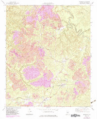
1974 Map of Brookwood
USGS Topo · Published 1983About this map
Industrial activity and small coal settlements define this Tuscaloosa County landscape during the mid-1970s. Numerous areas marked as Strip Mine dominate the topography, illustrating the heavy extraction that shaped the terrain around Brookwood and East Brookwood. The infrastructure of the era is clearly visible, with the Seaboard rail line and an old railroad grade cutting through the hills to serve these mining operations. Local life is anchored by traditional landmarks such as Antioch Ch and Friendship Ch, along with smaller communities like Kellerman and Searles.
Find a feature on this map
35 named features on this map. Tap any name to fly to it.
Don’t see what you’re looking for? This feature index may not catch every label — zoom into the map to look around manually.
Map Details
Editions of this 1974 Brookwood Map
2 editions found
Other maps of this area

1899 · Brookwood
USGS Topo · 1:125,000

1927 · Adger
USGS Topo · 1:48,000

1929 · Searles
USGS Topo · 1:48,000

1931 · Cottondale
USGS Topo · 1:48,000

1932 · Yolande
USGS Topo · 1:62,500

1934 · Searles
USGS Topo · 1:62,500

1934 · Cottondale
USGS Topo · 1:62,500

1934 · Blocton
USGS Topo · 1:48,000

1935 · Yolande
USGS Topo · 1:62,500

1940 · Blocton
USGS Topo · 1:62,500