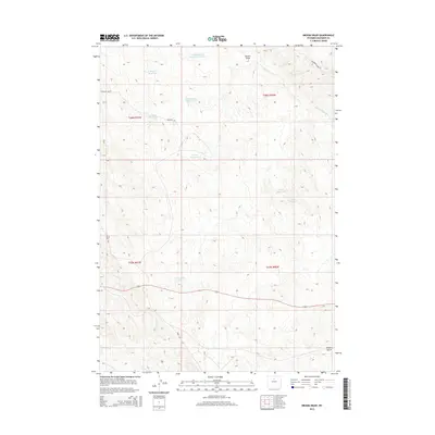
2015 Map of Broom Draw
USGS Topo · Published 2015About this map
Broom Draw and Meyers Gulch define the arid landscape of this Washakie County region, where water management is central to land use. The presence of numerous small reservoirs, including Hidden Dome Reservoir Number 1, Silted Reservoir, and Pumpjack Reservoir, suggests a landscape engineered for livestock or industrial water storage in an otherwise dry environment. Transportation across these open ranges is facilitated by several named routes like Bonanza Rd and Bentonite Ridge Rd. The map also traces the drainage patterns of Big Cottonwood Cr and E Fork Sand Cr, providing a detailed look at the hydrology of the Big Horn Basin. While residential settlements are not indicated, the density of reservoirs like Hanger Reservoir and Charco Reservoir reveals how this territory has been partitioned and utilized for its resources.
Find a feature on this map
20 named features on this map. Tap any name to fly to it.
Don’t see what you’re looking for? This feature index may not catch every label — zoom into the map to look around manually.
Map Details
Editions of this 2015 Broom Draw Map
This is the sole edition of this map. No revisions or reprints were ever made.
Other maps of this area

1955 · Sheridan
USGS Topo · 1:250,000

1955 · Arminto
USGS Topo · 1:250,000

1958 · Sheridan
USGS Topo · 1:250,000

1958 · Arminto
USGS Topo · 1:250,000

1962 · Sheridan
USGS Topo · 1:250,000

1962 · Arminto
USGS Topo · 1:250,000

1966 · Cabin Fork
USGS Topo · 1:24,000
1966 · Banjo Flats East
USGS Topo · 1:24,000
1966 · Castle Gardens
USGS Topo · 1:24,000
1967 · Hyattville
USGS Topo · 1:24,000