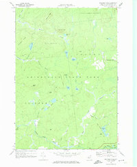
1970 Map of Brother Ponds
USGS Topo · Published 1972About this map
Adirondack State Park dominates this terrain, located within the townships of Clifton and Colton. The landscape is defined by a dense network of high-elevation water bodies and drainage systems, including the South Branch Grass River and the eponymous Brother Ponds. This 1970 survey illustrates a wilderness nearly devoid of permanent settlements, instead highlighting the topographical complexity of the North Country. Named elevations like Potter Mountain, Buckhorn Ridge, and Wilson Mtn surround interior basins like Dismal Swamp, creating a rugged isolation typical of the Western Adirondacks. Evidence of human passage is limited to trails and jeep tracks that connect secluded waters such as Clear Pond and Sampson Pond, suggesting an era focused on forestry and conservation within the State Forest Preserve.
Find a feature on this map
39 named features on this map. Tap any name to fly to it.
Don’t see what you’re looking for? This feature index may not catch every label — zoom into the map to look around manually.
Map Details
Editions of this 1970 Brother Ponds Map
This is the sole edition of this map. No revisions or reprints were ever made.
Other maps of this area

1907 · Tupper Lake
USGS Topo · 1:62,500

1919 · Cranberry Lake
USGS Topo · 1:62,500

1920 · Childwold
USGS Topo · 1:62,500

1921 · Cranberry Lake
USGS Topo · 1:62,500

1921 · Childwold
USGS Topo · 1:48,000

1921 · Stark
USGS Topo · 1:62,500

1922 · Childwold
USGS Topo · 1:62,500

1923 · Stark
USGS Topo · 1:62,500

1931 · Cranberry Lake
USGS Topo · 1:62,500

1940 · Stark
USGS Topo · 1:62,500