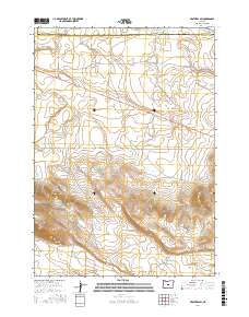
2017 Map of Brothers SW
USGS Topo · Published 2017About this map
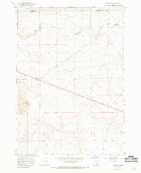
The boundary between Crook County and Deschutes County runs along the northern edge of this high-desert plateau, where the landscape is defined by drainage patterns and arid elevation features. The volcanic character of the region is evident at Pine Ridge, while the northern terrain is marked by the presence of Houston Reservoir Number Two and Houston Reservoir Number Three. These water management features sit just south of Merrill Rd, illustrating the intersection of modern utility and remote rangeland. The ephemeral course of Dry River cuts through the northeast, tracing a path through the various sections of Township 19 South, Range 17 East and Township 20 South, Range 17 East. This map provides a clear record of land divisions and topographical contours that shaped the development of central Oregon's interior basin.
Find a feature on this map
10 named features on this map. Tap any name to fly to it.
Don’t see what you’re looking for? This feature index may not catch every label — zoom into the map to look around manually.
Map Details
Editions of this 2017 Brothers SW Map
This is the sole edition of this map. No revisions or reprints were ever made.
Other maps of this area

1955 · Crescent
USGS Topo · 1:250,000

1957 · Crescent
USGS Topo · 1:250,000

1958 · Crescent
USGS Topo · 1:250,000

1966 · Millican SE
USGS Topo · 1:24,000

1967 · Brothers NW
USGS Topo · 1:24,000
1967 · Sugarloaf Butte
USGS Topo · 1:24,000
1967 · Brothers SW
USGS Topo · 1:24,000
1967 · West Butte
USGS Topo · 1:24,000
1967 · Brothers
USGS Topo · 1:24,000

1970 · Crescent
USGS Topo · 1:250,000