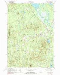
1964 Map of Brownfield
USGS Topo · Published 1990About this map
The Saco River and the Maine Central Railroad anchor this 1964 survey of southern Oxford County, showing the intersection of river transport and rail infrastructure. Settlement patterns are concentrated along the valley floor, with Brownfield and its satellite communities of East Brownfield and West Brownfield serving as local hubs. The landscape is dotted with small, family-named burial grounds like Merrill Cem and Wentworth Cem, providing specific points of interest for genealogical research. The southern portion of the quadrangle is dominated by the Burnt Meadow Mountains, including Stone Mtn and Sugarloaf. To the north, the terrain transitions to lower-lying wetlands and ponds near Lovewell Pond, where the Eastern Slopes Regional Airport indicates the modernizing infrastructure of the mid-20th century.
Find a feature on this map
63 named features on this map. Tap any name to fly to it.
Don’t see what you’re looking for? This feature index may not catch every label — zoom into the map to look around manually.
Map Details
Editions of this 1964 Brownfield Map
2 editions found
Other maps of this area

1894 · North Conway
USGS Topo · 1:62,500

1896 · North Conway
USGS Topo · 1:62,500

1909 · Fryeburg
USGS Topo · 1:62,500

1910 · Kezar Falls
USGS Topo · 1:48,000

1911 · Fryeburg
USGS Topo · 1:62,500

1911 · Kezar Falls
USGS Topo · 1:62,500

1930 · Ossipee Lake
USGS Topo · 1:62,500

1941 · Fryeburg
USGS Topo · 1:62,500

1942 · North Conway
USGS Topo · 1:62,500

1945 · North Conway
USGS Topo · 1:62,500