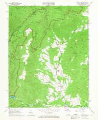
1965 Map of Browns Cove
USGS Topo · Published 1966About this map
The Doyles River valley anchors this mid-century view of the Blue Ridge foothills, where small communities like Browns Cove and Mountfair persist at the edge of Shenandoah National Park. The landscape is a study in transition between the protected mountainous terrain of the Blue Ridge and the agricultural valley floors. A notable archaeological and historical marker is the Civil War Gun Emplacement near Browns Gap, indicating the strategic importance of these mountain passes during previous centuries. In the lower elevations, rural life is centered around local landmarks such as Browns Cove Ch, Mt Carmel Ch, and the Sandridge Cem. The southern edge of the map shows the Charlottesville Reservoir and Camp Sugar Hollow along the Moormans River, highlighting the area's role in regional water management and recreation during the 1960s.
Find a feature on this map
54 named features on this map. Tap any name to fly to it.
Don’t see what you’re looking for? This feature index may not catch every label — zoom into the map to look around manually.
Map Details
Editions of this 1965 Browns Cove Map
3 editions found

Other maps of this area

1892 · Harrisonburg
USGS Topo · 1:125,000

1931 · University
USGS Topo · 1:62,500

1934 · Waynesboro
USGS Topo · 1:48,000

1935 · University
USGS Topo · 1:62,500

1937 · Elkton
USGS Topo · 1:62,500

1939 · Waynesboro
USGS Topo · 1:62,500

1941 · Harrisonburg
USGS Topo · 1:62,500

1943 · Harrisonburg
USGS Topo · 1:62,500

1949 · Charlottesville
USGS Topo · 1:250,000

1956 · Charlottesville
USGS Topo · 1:250,000