
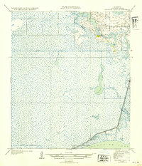
1935 Map of Browns Lake
USGS Topo · Published 1935About this map
Vincent Island and the surrounding marshlands of Cameron Parish are captured here as they appeared in the mid-1930s. This coastal landscape is defined by its complex network of waterways, including Starks Canal and Hog Island Gully, which cut through the low-lying terrain north of Calcasieu Lake. On higher ground, the Hackberry Sch stands as a primary community landmark, while Back Ridge offers a slight elevation in an otherwise water-saturated environment. Surveyed just after the Air Corps provided aerial photography for more accurate drainage mapping, the sheet documents early infrastructure such as State Highway No 104. Named landmarks like China and Brown appear as triangulation stations or specific locales, serving as essential reference points for those tracing the historical geography of this section of coastal Louisiana before modern development significantly altered the shoreline.
Find a feature on this map
13 named features on this map. Tap any name to fly to it.
Don’t see what you’re looking for? This feature index may not catch every label — zoom into the map to look around manually.
Map Details
Editions of this 1935 Browns Lake Map
2 editions found
Other maps of this area

1932 · Moss Lake
USGS Topo · 1:31,680

1932 · Orange
USGS Topo · 1:62,500

1934 · Cameron
USGS Topo · 1:24,000

1934 · Holly Beach
USGS Topo · 1:24,000

1934 · Peveto Beach
USGS Topo · 1:24,000

1934 · Browns Lake
USGS Topo · 1:24,000

1934 · Five Lakes
USGS Topo · 1:24,000

1935 · Peveto Beach
USGS Topo · 1:31,680

1935 · Cameron
USGS Topo · 1:31,680

1935 · Five Lakes
USGS Topo · 1:31,680