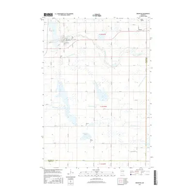
2016 Map of Brownton
USGS Topo · Published 2016About this map
Brownton stands as a central hub in this section of McLeod County, situated at the intersection of several local routes such as Division St W and 65th Ave. The surrounding landscape is defined by its agricultural heritage and an intricate network of waterways, including Buffalo Cr and High Island Cr. For genealogists, the map is particularly valuable as it identifies several burial grounds including Oak Grove Cem, Immanuel Cem, and Streich Cem, providing a direct link to the area's early families. Further east, the smaller settlement of Sumter sits near the tracks, while the southern reaches transition into Sibley County. This survey illustrates how human drainage efforts, noted by County Ditch Number Thirty and Judicial Ditch Number Nineteen, have historically modified the prairie wetlands to support the region's farming economy.
Find a feature on this map
65 named features on this map. Tap any name to fly to it.
Don’t see what you’re looking for? This feature index may not catch every label — zoom into the map to look around manually.
Map Details
Editions of this 2016 Brownton Map
This is the sole edition of this map. No revisions or reprints were ever made.
Other maps of this area

1953 · New Ulm
USGS Topo · 1:250,000

1957 · New Ulm
USGS Topo · 1:250,000

1958 · New Ulm
USGS Topo · 1:250,000

1958 · Gaylord
USGS Topo · 1:62,500

1958 · Glencoe
USGS Topo · 1:62,500

1958 · Winthrop
USGS Topo · 1:62,500

1958 · Hutchinson
USGS Topo · 1:62,500

1967 · New Ulm
USGS Topo · 1:250,000
1982 · Heatwole
USGS Topo · 1:24,000
1982 · Biscay
USGS Topo · 1:24,000