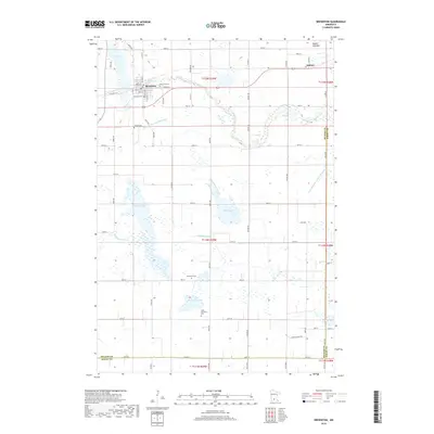
2019 Map of Brownton
USGS Topo · Published 2019About this map
Brownton and the village of Sumter anchor this rural landscape in western McLeod County, where the plains are marked by a complex system of agricultural drainage and natural water bodies. The terrain is defined by the winding course of Buffalo Cr to the north and High Island Cr to the south, which navigate a series of basins including Lake Addie, Bakers Lake, and King's Lake. This survey illustrates the high density of small-town landmarks and rural burial sites that serve as vital records for local genealogists, ranging from Oak Grove Cem near the town center to the outlying Streich Cem. The regular grid of section roads and county highways, such as Co HWY 32 and Co RD 65, frames a landscape shaped by both natural hydrology and human intervention, visible in the engineered paths of County Ditch Number Thirty and Judicial Ditch Number Nineteen.
Find a feature on this map
70 named features on this map. Tap any name to fly to it.
Don’t see what you’re looking for? This feature index may not catch every label — zoom into the map to look around manually.
Map Details
Editions of this 2019 Brownton Map
This is the sole edition of this map. No revisions or reprints were ever made.
Other maps of this area

1953 · New Ulm
USGS Topo · 1:250,000

1957 · New Ulm
USGS Topo · 1:250,000

1958 · New Ulm
USGS Topo · 1:250,000

1958 · Gaylord
USGS Topo · 1:62,500

1958 · Glencoe
USGS Topo · 1:62,500

1958 · Winthrop
USGS Topo · 1:62,500

1958 · Hutchinson
USGS Topo · 1:62,500

1967 · New Ulm
USGS Topo · 1:250,000
1982 · Heatwole
USGS Topo · 1:24,000
1982 · Biscay
USGS Topo · 1:24,000