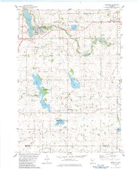
1982 Map of Brownton
USGS Topo · Published 1983About this map
Brownton and the village of Sumter define the northern corridor of this McLeod County landscape during the early 1980s. The agricultural character of the region is evident in the extensive network of drainage infrastructure, including Judicial Ditch No 18 and several others that manage the water levels around natural basins like Addie Lake and Bakers Lake. The Chicago Milwaukee St Paul and Pacific railroad cuts a straight path through the northern tier, passing directly through the local settlements and facilitating the movement of goods across the prairie.
Find a feature on this map
30 named features on this map. Tap any name to fly to it.
Don’t see what you’re looking for? This feature index may not catch every label — zoom into the map to look around manually.
Map Details
Editions of this 1982 Brownton Map
This is the sole edition of this map. No revisions or reprints were ever made.
Other maps of this area

1953 · New Ulm
USGS Topo · 1:250,000

1957 · New Ulm
USGS Topo · 1:250,000

1958 · New Ulm
USGS Topo · 1:250,000

1958 · Gaylord
USGS Topo · 1:62,500

1958 · Glencoe
USGS Topo · 1:62,500

1958 · Winthrop
USGS Topo · 1:62,500

1958 · Hutchinson
USGS Topo · 1:62,500

1967 · New Ulm
USGS Topo · 1:250,000
1982 · Heatwole
USGS Topo · 1:24,000
1982 · Biscay
USGS Topo · 1:24,000