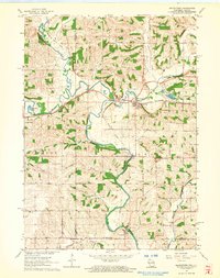
1962 Map of Browntown
USGS Topo · Published 1964About this map
The winding course of the Pecatonica River and its East Branch dominate this borderland landscape between Wisconsin and Illinois. In the early 1960s, the village of Browntown served as a key point along the Chicago Milwaukee St Paul and Pacific railroad, which follows the river valley through Dill and South Wayne. This area is characterized by a dense network of small rural institutions and family-named landmarks that reflect a deeply rooted agricultural community. Genealogists can locate several burial grounds, including La Due Cem, Michael Cem, and Saucerman Cem, alongside local education centers like Cadiz Center Sch and Rush Sch. Downstream near the state line, the settlement of Martintown sits near a Gaging Station and the Martin Cem, while the historic Lattice Bridge spans the water further north.
Find a feature on this map
34 named features on this map. Tap any name to fly to it.
Don’t see what you’re looking for? This feature index may not catch every label — zoom into the map to look around manually.
Map Details
Editions of this 1962 Browntown Map
2 editions found
Other maps of this area

1920 · Monroe
USGS Topo · 1:62,500

1922 · Monroe
USGS Topo · 1:62,500

1923 · South Wayne
USGS Topo · 1:62,500

1937 · Lena
USGS Topo · 1:48,000

1939 · Freeport
USGS Topo · 1:48,000

1942 · Lena
USGS Topo · 1:62,500

1943 · Lena
USGS Topo · 1:62,500

1944 · Freeport
USGS Topo · 1:62,500

1954 · Rockford
USGS Topo · 1:250,000

1955 · Rockford
USGS Topo · 1:250,000