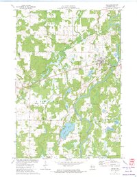
1972 Map of Bruce
USGS Topo · Published 1974About this map
The Chippewa River flows prominently through this Rusk County landscape, defining the local geography as it passes the village of Bruce. The settlement patterns here follow the corridor established by the Soo Line railroad, which links the primary population centers of Bruce and the neighboring community of Apollonia. Significant water bodies such as Amacoy Lake, Bruce Lake, and Caley Lake dominate the southern and central terrain, many of which are flanked by recreation-oriented landmarks like the Picnic Area and Youth Camp. Genealogists may find particular value in the documentation of local burial sites, including St Marys Cem and a second Cem near Apollonia. The mapping of Townline Road and Ranch Road highlights the rural infrastructure that supported the area's transition into the late 20th century, while various Gravel Pits indicate the importance of local material extraction.
Find a feature on this map
34 named features on this map. Tap any name to fly to it.
Don’t see what you’re looking for? This feature index may not catch every label — zoom into the map to look around manually.
Map Details
Editions of this 1972 Bruce Map
This is the sole edition of this map. No revisions or reprints were ever made.
Other maps of this area

1944 · Exeland
USGS Topo · 1:48,000

1945 · Meteor
USGS Topo · 1:48,000

1947 · Exeland
USGS Topo · 1:48,000

1948 · Weyerhauser
USGS Topo · 1:48,000

1948 · Ladysmith
USGS Topo · 1:48,000

1949 · Meteor
USGS Topo · 1:48,000

1950 · Weyerhauser
USGS Topo · 1:48,000

1950 · Ladysmith
USGS Topo · 1:48,000

1953 · Rice Lake
USGS Topo · 1:250,000

1959 · Rice Lake
USGS Topo · 1:250,000