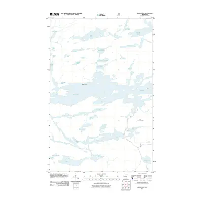
2011 Map of Brule Lake
USGS Topo · Published 2011About this map
Brule Lake Lookout Tower stands as a primary landmark in this densely lacustrine landscape of northeastern Minnesota. The area is defined by a complex network of interconnected water bodies, dominated by the expansive Brule Lake and its distinctive terrain features like Fishbox Island and Jock Mock Point. This 2011 survey illustrates a wilderness character where transportation is limited primarily to the southern corridor via Brule Lake Rd, leaving the northern chain of lakes—including Winchell Lake, Davis Lake, and the series of North Cone Lake, Middle Cone Lake, and South Cone Lake—accessible largely by water or portage. The naming conventions, such as Famine Lake and Poverty Lake, suggest a demanding history for early travelers through this glacial terrain, while features like Wanihigan Lake reflect the region's indigenous and fur-trading heritage.
Find a feature on this map
43 named features on this map. Tap any name to fly to it.
Don’t see what you’re looking for? This feature index may not catch every label — zoom into the map to look around manually.
Map Details
Editions of this 2011 Brule Lake Map
This is the sole edition of this map. No revisions or reprints were ever made.
Other maps of this area

1919 · Brule Lake
USGS Topo · 1:62,500

1954 · Two Harbors
USGS Topo · 1:250,000

1957 · Two Harbors
USGS Topo · 1:250,000

1957 · Quetico
USGS Topo · 1:250,000

1958 · Two Harbors
USGS Topo · 1:250,000

1960 · Tait Lake
USGS Topo · 1:24,000

1960 · Mark Lake
USGS Topo · 1:24,000
1960 · South Lake
USGS Topo · 1:24,000

1960 · Sawbill Camp
USGS Topo · 1:24,000
1960 · Eagle Mountain
USGS Topo · 1:24,000