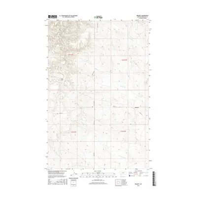
2017 Map of Brusett
USGS Topo · Published 2017About this map
Brusett sits at the junction of Brusett Rd and Edwards Rd in this contemporary look at Garfield County's high plains. The landscape is defined by its drainage patterns, most notably the winding courses of Smoky Butte Cr and Seven-Blackfoot Cr. Historical routes are echoed by the presence of the Loomis & Clark Trl, which traverses the northern reaches of the quadrangle near Clay Coulee. This survey illustrates the sparse, high-desert character of central Montana, where water determines the naming of the land. Landmarks like Butts Coulee and the headwaters of N Fork Lone Tree Cr reflect a geography where seasonal flows have carved the terrain into distinct coulees and ridges, essential for navigation in such an expansive ranching environment.
Find a feature on this map
15 named features on this map. Tap any name to fly to it.
Don’t see what you’re looking for? This feature index may not catch every label — zoom into the map to look around manually.
Map Details
Editions of this 2017 Brusett Map
This is the sole edition of this map. No revisions or reprints were ever made.
Other maps of this area
1954 · Jordan
USGS Topo · 1:250,000
1956 · Jordan
USGS Topo · 1:250,000
1958 · Jordan
USGS Topo · 1:250,000
1964 · Jordan
USGS Topo · 1:250,000
1971 · Hell Hollow
USGS Topo · 1:24,000
1971 · Sawmill Creek
USGS Topo · 1:24,000
1971 · Chalk Butte
USGS Topo · 1:24,000
1978 · Fort Peck Lake West
USGS Topo · 1:100,000
1983 · Steve Forks
USGS Topo · 1:24,000
1983 · Blackfoot School
USGS Topo · 1:24,000