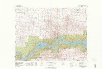
1978 Map of Fort Peck Lake West
USGS Topo · Published 1978About this map
The Missouri River and the expansive Fort Peck Lake dominate the southern portion of this landscape, where the reservoir winds through the Charles M Russell National Wildlife Range. To the northwest, the Ul Bend National Wildlife Refuge marks a significant protected area along the water’s edge. This 1970s view reveals a sparsely populated region of Phillips County, defined by isolated settlements such as Regina PO and Sun Prairie located near the Sun Prairie Flats. The map illustrates a landscape of complex drainage systems including Beaver Creek and Frenchman Creek, alongside numerous coulees like Desert Coulee. Human activity is noted through scattered infrastructure such as a Coal Mine and a remote Landing Strip, reflecting the rural industrial and transport needs of this portion of the Montana plains.
Find a feature on this map
29 named features on this map. Tap any name to fly to it.
Don’t see what you’re looking for? This feature index may not catch every label — zoom into the map to look around manually.
Map Details
Editions of this 1978 Fort Peck Lake West Map
2 editions found
Other maps of this area

1943 · Glasgow
USGS Topo · 1:125,000

1953 · Havre
USGS Topo · 1:250,000

1954 · Jordan
USGS Topo · 1:250,000

1954 · Glasgow
USGS Topo · 1:250,000

1954 · Lewistown
USGS Topo · 1:250,000

1956 · Jordan
USGS Topo · 1:250,000

1957 · Glasgow
USGS Topo · 1:250,000

1957 · Havre
USGS Topo · 1:250,000

1958 · Glasgow
USGS Topo · 1:250,000

1958 · Jordan
USGS Topo · 1:250,000