
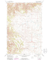
1971 Map of Chalk Butte
USGS Topo · Published 1974About this map
The Charles M Russell National Wildlife Range dominates the northern portion of this landscape, marking a protected transition between the upland breaks and the Missouri River drainage. This 1971 survey captures the area around the small settlement of Brusett, showing a sparse network of unimproved roads and cattle tanks characteristic of Garfield County ranching life in the early 1970s. The terrain is defined by the sharp relief of Chalk Butte in the south and the drainage systems of Snow Creek and the South Fork Snow Creek, which cut deep coulees through the high plains. Researchers will find the map particularly useful for tracing the early fence lines and stock water improvements that supported mid-century livestock operations in this isolated section of the Montana badlands.
Find a feature on this map
9 named features on this map. Tap any name to fly to it.
Don’t see what you’re looking for? This feature index may not catch every label — zoom into the map to look around manually.
Map Details
Editions of this 1971 Chalk Butte Map
2 editions found
Other maps of this area

1954 · Jordan
USGS Topo · 1:250,000

1956 · Jordan
USGS Topo · 1:250,000

1958 · Jordan
USGS Topo · 1:250,000

1964 · Jordan
USGS Topo · 1:250,000

1971 · Hell Hollow
USGS Topo · 1:24,000

1971 · Wolfe Coulee
USGS Topo · 1:24,000

1971 · Wagon Coulee
USGS Topo · 1:24,000

1971 · Sawmill Creek
USGS Topo · 1:24,000
1971 · Swede Ridge
USGS Topo · 1:24,000

1978 · Fort Peck Lake West
USGS Topo · 1:100,000