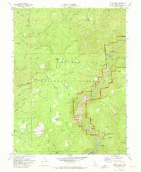
1970 Map of Brush Creek
USGS Topo · Published 1974About this map
Plumas National Forest dominates this landscape in the Sierra Nevada foothills, where the Middle Fork Feather Wild and Scenic River carves deep through Bald Rock Canyon. The map documents a period of significant hydraulic transition, showing the early boundaries of the Lake Oroville State Recreation Area as the newly formed reservoir began to shape the southern terrain. Evidence of older resource extraction persists through Dredge Tailings along French Creek, while small settlements and historic locations like Mountain House and the Junction House (Site) anchor the high ridges. Topographic landmarks such as Big Bald Rock and Bald Rock Dome highlight the prominent granitic features of the region. This 1970 field-checked survey captures the area just as the modern recreational and water management era was taking hold over the historic mining and transit routes of Butte County.
Find a feature on this map
71 named features on this map. Tap any name to fly to it.
Don’t see what you’re looking for? This feature index may not catch every label — zoom into the map to look around manually.
Map Details
Editions of this 1970 Brush Creek Map
2 editions found
Other maps of this area

1888 · Bidwell Bar
USGS Topo · 1:125,000

1891 · Bidwell Bar
USGS Topo · 1:125,000

1893 · Bidwell Bar
USGS Topo · 1:125,000

1895 · Bidwell Bar
USGS Topo · 1:125,000

1897 · Bidwell Bar
USGS Topo · 1:125,000
1947 · Bidwell Bar
USGS Topo · 1:24,000
1947 · Brush Creek
USGS Topo · 1:24,000

1948 · Big Bend Mtn
USGS Topo · 1:62,500
1948 · Mooreville Ridge
USGS Topo · 1:62,500
1948 · Las Plumas
USGS Topo · 1:24,000