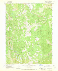
1966 Map of Brushy Mtn
USGS Topo · Published 1969About this map
Mendocino National Forest defines the character of this mid-1960s survey, capturing a rugged landscape dominated by high ridges and deep drainage basins in Northern California. The Eel River snakes through the southern portion of the sheet, providing a primary hydrological anchor for a network of tributaries including English Creek and Bear Creek. The terrain is marked by significant topographical landmarks such as Brushy Mtn and Bald Mountain, which overlook the expansive Eden Valley to the north. Historical land use is evidenced by several remote improvements, including Corrals and a Spring Camp located along the high ground of Box Spring Ridge. These features, connected by a network of Jeep Trails, suggest a period of active rangeland management and seasonal forestry work within the national forest boundary.
Find a feature on this map
33 named features on this map. Tap any name to fly to it.
Don’t see what you’re looking for? This feature index may not catch every label — zoom into the map to look around manually.
Map Details
Editions of this 1966 Brushy Mtn Map
4 editions found
Other maps of this area

1922 · Willits
USGS Topo · 1:62,500

1929 · Eden Valley
USGS Topo · 1:62,500

1942 · Willits
USGS Topo · 1:62,500

1943 · Pomo
USGS Topo · 1:62,500

1944 · Willits
USGS Topo · 1:62,500

1951 · Laytonville
USGS Topo · 1:62,500

1952 · Eden Valley
USGS Topo · 1:62,500

1957 · Ukiah
USGS Topo · 1:250,000

1960 · Ukiah
USGS Topo · 1:250,000

1960 · Potter Valley
USGS Topo · 1:62,500