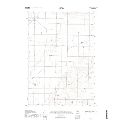
2018 Map of Bryant
USGS Topo · Published 2018About this map
Neva and Bryant anchor the rural landscape of Langlade County in this 2018 survey, where agricultural land meets the complex waterways of northern Wisconsin. The E Br Eau Claire River winds through the northwest corner, while the Spring Brook system feeds into local landmarks like 25 Reservoir and Schmuhl Lake. Family and community history is anchored by the Neva Cem and Bent Cem, providing vital points of reference for genealogists. This area maintains its early 20th-century settlement pattern, visible in the grid of local roads like Antigo Polar Rd and Price Polar Rd. The presence of the Langlade County Airport in the southwest quadrant reflects the region's modern infrastructure within a traditionally agrarian and timber-rich environment. This topographic study captures the drainage patterns and land use that have shaped the county's development from its pioneering roots through the 21st century.
Find a feature on this map
51 named features on this map. Tap any name to fly to it.
Don’t see what you’re looking for? This feature index may not catch every label — zoom into the map to look around manually.
Map Details
Editions of this 2018 Bryant Map
This is the sole edition of this map. No revisions or reprints were ever made.
Other maps of this area

1942 · Elcho
USGS Topo · 1:48,000

1942 · Pearson
USGS Topo · 1:48,000

1950 · Elcho
USGS Topo · 1:48,000

1950 · Lily
USGS Topo · 1:48,000

1952 · Antigo
USGS Topo · 1:48,000

1952 · White Lake
USGS Topo · 1:48,000

1954 · Iron Mountain
USGS Topo · 1:250,000

1959 · Iron Mountain
USGS Topo · 1:250,000
1973 · Antigo
USGS Topo · 1:24,000
1973 · Bryant
USGS Topo · 1:24,000