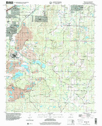
1994 Map of Bryant
USGS Topo · Published 2000About this map
Extensive industrial activity and the expansion of suburban settlements define this landscape south of Little Rock during the 1990s. The western portion of the quadrangle is dominated by significant excavation sites, labeled simply as Mine, accompanied by several Tailings Ponds and a Mine Dump near Bryant. This resource extraction exists alongside established communities like Alexander and Shannon Hills, where residential growth is marked by several school campuses and Wilbur Mills Park.
Find a feature on this map
66 named features on this map. Tap any name to fly to it.
Don’t see what you’re looking for? This feature index may not catch every label — zoom into the map to look around manually.
Map Details
Editions of this 1994 Bryant Map
This is the sole edition of this map. No revisions or reprints were ever made.
Other maps of this area

1890 · Benton
USGS Topo · 1:125,000

1891 · Little Rock
USGS Topo · 1:125,000

1893 · Little Rock
USGS Topo · 1:125,000

1894 · Benton
USGS Topo · 1:125,000

1935 · Little Rock
USGS Topo · 1:24,000

1935 · Alexander
USGS Topo · 1:48,000

1938 · Benton
USGS Topo · 1:48,000

1941 · Alexander
USGS Topo · 1:62,500

1944 · Benton
USGS Topo · 1:62,500

1944 · Alexander
USGS Topo · 1:31,680