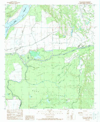
1988 Map of Buck Island
USGS Topo · Published 1988About this map
Buck Island and Tansey Island dominate this reach of the lower Mississippi floodplains, where the border between Concordia Parish and Adams County follows the shifting path of the river. The complex hydrology of the late 1980s is on full display, showcasing the dramatic engineering of the Glasscock Cutoff and the Homochitto River Canal. These man-made adjustments to the natural drainage systems were designed to manage the immense power of the Mississippi River, which otherwise carved landmarks like Esperance Point and Glasscock Point.
Find a feature on this map
30 named features on this map. Tap any name to fly to it.
Don’t see what you’re looking for? This feature index may not catch every label — zoom into the map to look around manually.
Map Details
Editions of this 1988 Buck Island Map
This is the sole edition of this map. No revisions or reprints were ever made.
Other maps of this area

1936 · Woodville
USGS Topo · 1:62,500

1939 · Kingston
USGS Topo · 1:62,500

1939 · Artonish
USGS Topo · 1:62,500

1939 · Deer Park
USGS Topo · 1:62,500

1953 · Natchez
USGS Topo · 1:250,000

1954 · Artonish
USGS Topo · 1:62,500

1955 · Artonish
USGS Topo · 1:62,500

1956 · Natchez
USGS Topo · 1:250,000

1958 · Artonish
USGS Topo · 1:62,500

1958 · Woodville
USGS Topo · 1:62,500