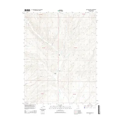
2014 Map of Buck Wash Well
USGS Topo · Published 2014About this map
Camp Valley and Meadow Valley define this high-desert basin in Lincoln County, where seasonal drainage networks create a complex system of washes. The central landmark, Buck Wash Well, underscores the critical importance of water access in this arid landscape. This 2014 survey documents a network of primitive corridors including Camp Valley Rd and Lyon Spring Rd that connect isolated valley floors across the townships of t4n r69e and t4n r70e. The terrain is characterized by numerous intersecting channels such as Camp Valley Cr and Meadow Valley Wash, alongside more distant features like Wildcat Wash and Buster Wash. These labels reflect a legacy of ranching and land management in a region defined by its hydrographic basins and expansive public land boundaries.
Find a feature on this map
28 named features on this map. Tap any name to fly to it.
Don’t see what you’re looking for? This feature index may not catch every label — zoom into the map to look around manually.
Map Details
Editions of this 2014 Buck Wash Well Map
This is the sole edition of this map. No revisions or reprints were ever made.
Other maps of this area

1956 · Lund
USGS Topo · 1:250,000

1960 · Lund
USGS Topo · 1:250,000

1970 · Pierson Summit
USGS Topo · 1:24,000

1970 · Parsnip Peak
USGS Topo · 1:24,000

1972 · Gleason Basin
USGS Topo · 1:24,000

1972 · White Rock Peak
USGS Topo · 1:24,000
1972 · Rice Mountain
USGS Topo · 1:24,000

1972 · Buck Wash Well
USGS Topo · 1:24,000
1972 · Eagle Valley Reservoir
USGS Topo · 1:24,000

1972 · Miller Canyon
USGS Topo · 1:24,000