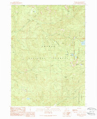
1989 Map of Buckeye Lake
USGS Topo · Published 1990About this map
The South Umpqua River and its numerous tributaries, including Black Rock Fork and Buckeye Creek, dominate this mountainous terrain within the Umpqua National Forest. The landscape is a network of ridges and drainages, marked by distinctive high points like Castle Rock and the meadows surrounding Grasshopper Mountain. While largely wilderness, human activity is evident through established recreational sites such as Camp Comfort Campground and Fish Lake Campground, alongside the remote Emerson Ranch.
Find a feature on this map
32 named features on this map. Tap any name to fly to it.
Don’t see what you’re looking for? This feature index may not catch every label — zoom into the map to look around manually.
Map Details
Editions of this 1989 Buckeye Lake Map
This is the sole edition of this map. No revisions or reprints were ever made.
Other maps of this area

1891 · Ashland
USGS Topo · 1:250,000

1893 · Ashland
USGS Topo · 1:250,000

1897 · Ashland
USGS Topo · 1:250,000

1917 · Diamond Lake
USGS Topo · 1:125,000

1944 · Abbott Butte
USGS Topo · 1:62,500

1947 · Abbott Butte
USGS Topo · 1:62,500

1955 · Quartz Mtn
USGS Topo · 1:62,500

1955 · Medford
USGS Topo · 1:250,000

1956 · Garwood Butte
USGS Topo · 1:62,500

1956 · Prospect
USGS Topo · 1:62,500