
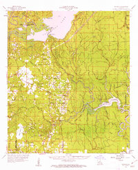
1959 Map of Buckeye
USGS Topo · Published 1960About this map
Catahoula Lake dominates the northwest corner of this Central Louisiana landscape, where the shifting boundaries of Grant, Rapides, LaSalle, and Catahoula Parishes meet. The terrain is a complex network of bayous and sloughs, including Alligator Bayou and Camels Slough, punctuated by prairies like Catfish Prairie and Vasher Prairie. In 1959, the region supported numerous small rural communities and family-centered landmarks, such as Buckeye, Deville, and Holloway. Genealogists may find value in the many documented places of worship and burial, including Bethel Ch, Marthas Chapel, and the Paul Cem. Industrial footprints are evident through several petroleum developments like the Cypress Bayou Oil Field and the North Saline Lake Oil Field, while remnants of former infrastructure appear as an Old Railroad Grade cutting through the woodlands near Long Prairie.
Find a feature on this map
85 named features on this map. Tap any name to fly to it.
Don’t see what you’re looking for? This feature index may not catch every label — zoom into the map to look around manually.
Map Details
Editions of this 1959 Buckeye Map
2 editions found
Other maps of this area

1935 · Tooleys
USGS Topo · 1:62,500

1935 · Lecompte
USGS Topo · 1:62,500

1936 · Pollock
USGS Topo · 1:62,500

1940 · Marksville
USGS Topo · 1:62,500

1941 · Manifest
USGS Topo · 1:62,500

1941 · Jena
USGS Topo · 1:62,500

1941 · Voorhies
USGS Topo · 1:62,500

1941 · Alexandria
USGS Topo · 1:62,500

1941 · Buckeye
USGS Topo · 1:62,500

1941 · Pollock
USGS Topo · 1:62,500