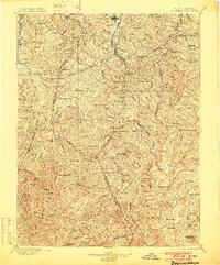
1896 Map of Buckhannon
USGS Topo · Published 1902About this map
Buckhannon serves as the focal point for this survey of the Allegheny Highlands, conducted at the end of the 19th century as logging and rail lines began to penetrate deep into the mountain ridges. The geography is defined by high elevations like Turkey Bone Mtn. and Point Mountain, which partitioned early settlements along the winding forks of the Buckhannon Run and the West Fork Monongahela River.
Find a feature on this map
136 named features on this map. Tap any name to fly to it.
Don’t see what you’re looking for? This feature index may not catch every label — zoom into the map to look around manually.
Map Details
Editions of this 1896 Buckhannon Map
3 editions found

Other maps of this area

1886 · St. George
USGS Topo · 1:125,000

1889 · Nicholas
USGS Topo · 1:125,000

1889 · Beverly
USGS Topo · 1:125,000

1891 · Nicholas
USGS Topo · 1:125,000

1891 · Huntersville
USGS Topo · 1:125,000

1891 · St. George
USGS Topo · 1:125,000

1892 · Beverly
USGS Topo · 1:125,000

1893 · Buckhannon
USGS Topo · 1:125,000

1893 · Sutton
USGS Topo · 1:125,000

1894 · Huntersville
USGS Topo · 1:125,000