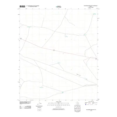
2010 Map of Buckhorn Draw East
USGS Topo · Published 2010About this map
Buckhorn Draw carves through this arid stretch of Hudspeth County, serving as the primary drainage feature in a landscape defined by water scarcity. The arrangement of livestock-supporting infrastructure illustrates the ranching heritage of West Texas, where named catchments like Number Eight Tank, Moccasin Tank, and Pole Line Tank are essential landmarks. Transportation is anchored by the shared alignment of 180 62, providing a modern corridor across the desert terrain. Other isolated water sources, such as Wonder Tank and Bluff Tank, indicate the careful management of surface runoff in an environment where natural springs are absent and every local depression, including Rock Tank and Gravel Tank, serves a vital purpose for land use and navigation.
Find a feature on this map
11 named features on this map. Tap any name to fly to it.
Don’t see what you’re looking for? This feature index may not catch every label — zoom into the map to look around manually.
Map Details
Editions of this 2010 Buckhorn Draw East Map
This is the sole edition of this map. No revisions or reprints were ever made.
Other maps of this area

1903 · Cerro Alto
USGS Topo · 1:125,000

1941 · Heuco Mountains
USGS Topo · 1:62,500

1942 · Borrego
USGS Topo · 1:62,500

1943 · Tepee Butte
USGS Topo · 1:62,500

1943 · San Antonio Mtn
USGS Topo · 1:62,500

1943 · Heuco Mountains
USGS Topo · 1:62,500

1954 · Van Horn
USGS Topo · 1:250,000

1958 · Van Horn
USGS Topo · 1:250,000
1978 · Wildhorse Draw
USGS Topo · 1:24,000
1978 · Molesworth Mesa South
USGS Topo · 1:24,000