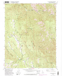
1992 Map of Buckingham Mtn
USGS Topo · Published 1995About this map
Buckingham Mountain and the surrounding Sierra National Forest define this Mariposa County landscape, where the high Sierra terrain meets the deep drainages of the South Fork Merced River. The map illustrates the transition from the high ridges of the Chowchilla Mountains and Snyder Ridge down to the settled pockets in Clarks Valley. Cultural landmarks of the early-to-mid 20th century are evident, including the Buckingham Mtn Sch and the Mariposa Guard Sta. Local industry and extraction are represented by the Early Mine and the Comet Mine (Aband), reflecting the region's mining heritage. Small settlements such as Jerseydale and Darrah anchor the southern portion of the sheet, connected by routes like Triangle Road. Notable water features such as Sims Cove and Peachtree Bar mark the river's path through the northern canyons.
Find a feature on this map
44 named features on this map. Tap any name to fly to it.
Don’t see what you’re looking for? This feature index may not catch every label — zoom into the map to look around manually.
Map Details
Editions of this 1992 Buckingham Mtn Map
2 editions found
Other maps of this area

1897 · Yosemite
USGS Topo · 1:125,000

1900 · Yosemite
USGS Topo · 1:125,000

1903 · Yosemite
USGS Topo · 1:125,000

1909 · Yosemite
USGS Topo · 1:125,000

1912 · Mariposa
USGS Topo · 1:125,000

1947 · Mariposa
USGS Topo · 1:24,000

1947 · El Portal
USGS Topo · 1:24,000

1947 · Mariposa
USGS Topo · 1:250,000

1947 · El Portal
USGS Topo · 1:62,500

1947 · Mariposa
USGS Topo · 1:62,500