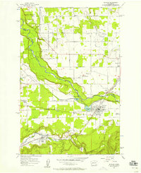
1956 Map of Buckley
USGS Topo · Published 1958About this map
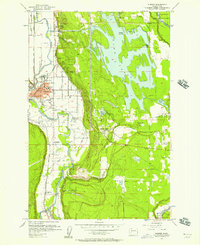
Muckleshoot Indian Reservation dominates the northern landscape of this 1950s survey, where the White River carves a deep valley between the fertile plateaus of Muckleshoot Prairie and Connells Prairie. The settlement pattern reflects a mix of agriculture and institutional development, with community centers like the Sunrise Grange and Finnish Hall serving rural families. In Buckley, the presence of the Rainier State Sch and the local High Sch marks the town as a regional hub, while the Northern Pacific railroad connects industrial points like South Prairie and Cascadia Jct. The map preserves the names of early settlements such as Wabash, Osceola, and Boise, alongside numerous family-named landmarks and water bodies like Newaukum Creek and Boise Creek.
Find a feature on this map
46 named features on this map. Tap any name to fly to it.
Don’t see what you’re looking for? This feature index may not catch every label — zoom into the map to look around manually.
Map Details
Editions of this 1956 Buckley Map
4 editions found
Other maps of this area

1897 · Tacoma
USGS Topo · 1:125,000

1900 · Tacoma
USGS Topo · 1:125,000

1913 · Cedar Lake
USGS Topo · 1:125,000

1942 · Lake Tapps
USGS Topo · 1:62,500

1944 · Lake Tapps
USGS Topo · 1:62,500

1949 · Black Diamond
USGS Topo · 1:24,000

1949 · Auburn
USGS Topo · 1:24,000

1953 · Cumberland
USGS Topo · 1:24,000

1956 · Orting
USGS Topo · 1:24,000
1956 · Sumner
USGS Topo · 1:24,000