
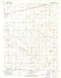
1969 Map of Bucklin NW
USGS Topo · Published 1971About this map
The Arkansas River carves a path through this section of Ford County, defining a landscape where agriculture and transit converge. The southern portion of the sheet is dominated by the town of Ford and its surrounding infrastructure, including the Ford corporate boundary, the C R I & P railroad line, and the Ford Cemetery. Evidence of local industry is visible through multiple Gravel Pits and the presence of Pipelines cutting across the northern sections of Spearville and Wheatland.
Find a feature on this map
14 named features on this map. Tap any name to fly to it.
Don’t see what you’re looking for? This feature index may not catch every label — zoom into the map to look around manually.
Map Details
Editions of this 1969 Bucklin NW Map
This is the sole edition of this map. No revisions or reprints were ever made.
Other maps of this area

1892 · Spearville
USGS Topo · 1:125,000

1894 · Spearville
USGS Topo · 1:125,000

1955 · Pratt
USGS Topo · 1:250,000

1959 · Pratt
USGS Topo · 1:250,000

1969 · Bucklin NE
USGS Topo · 1:24,000

1969 · Bucklin SE
USGS Topo · 1:24,000

1969 · Bucklin
USGS Topo · 1:24,000

1969 · Kingsdown
USGS Topo · 1:24,000

1969 · Ford
USGS Topo · 1:24,000
1972 · Bellefont
USGS Topo · 1:24,000