
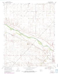
1969 Map of Ford
USGS Topo · Published 1971About this map
The Arkansas River cuts a wide, green swath southeast through the arid plains of Ford County, defining the agricultural and industrial character of the region. Near the river's bend sits the town of Ford, a focal point for local transportation where the Chicago Rock Island and Pacific railroad crosses the landscape. The reliance on the area's natural resources is evident in the numerous Gravel Pits and a Sandpit scattered along the river valley and near the railway, supporting the infrastructure of the surrounding Spearville and Ford townships. Further south, Mulberry Creek meanders toward the river, while a network of Pipelines and a Jeep Trail suggest a landscape actively utilized for both energy transport and rural access during the late 1960s.
Find a feature on this map
13 named features on this map. Tap any name to fly to it.
Don’t see what you’re looking for? This feature index may not catch every label — zoom into the map to look around manually.
Map Details
Editions of this 1969 Ford Map
2 editions found
Other maps of this area

1892 · Spearville
USGS Topo · 1:125,000

1894 · Spearville
USGS Topo · 1:125,000

1955 · Pratt
USGS Topo · 1:250,000

1959 · Pratt
USGS Topo · 1:250,000
1969 · Fort Dodge SW
USGS Topo · 1:24,000

1969 · Fort Dodge
USGS Topo · 1:24,000

1969 · Bucklin
USGS Topo · 1:24,000

1969 · Kingsdown
USGS Topo · 1:24,000

1969 · Bucklin NW
USGS Topo · 1:24,000
1972 · Bellefont
USGS Topo · 1:24,000