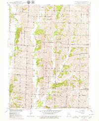
1949 Map of Bucklin NW
USGS Topo · Published 1979About this map
The agrarian landscape of Linn County near Johnstown is defined by the winding paths of West Yellow Creek and Winigan Creek, which carve through the townships of North Salem, Grantsville, and Baker. This 1949 topographic study, based in part on 1939 aerial photography, reveals a dense network of local landmarks essential to mid-century rural life. Numerous small schoolhouses, such as Thudium Sch and Hackler Sch, serve as focal points for the surrounding farmsteads, reflecting a period before widespread school consolidation.
Find a feature on this map
31 named features on this map. Tap any name to fly to it.
Don’t see what you’re looking for? This feature index may not catch every label — zoom into the map to look around manually.
Map Details
Editions of this 1949 Bucklin NW Map
2 editions found
Other maps of this area

1946 · Brookfield
USGS Topo · 1:62,500

1948 · Brookfield
USGS Topo · 1:62,500

1949 · Bucklin
USGS Topo · 1:24,000

1949 · Bucklin NW
USGS Topo · 1:24,000

1950 · Bucklin
USGS Topo · 1:24,000

1950 · New Cambria West
USGS Topo · 1:24,000

1950 · Bucklin NW
USGS Topo · 1:24,000

1951 · New Boston
USGS Topo · 1:24,000

1953 · Moberly
USGS Topo · 1:250,000

1954 · Centerville
USGS Topo · 1:250,000