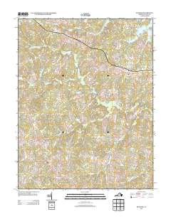
2013 Map of Buckner
USGS Topo · Published 2013About this map
Gardners Crossroads and Buckner anchor this landscape in central Virginia, where the terrain is defined by a dense network of minor waterways including the Little River and Long Creek. The presence of Swifts Mill at Swift Millpond reflects the historical importance of local water power for milling operations along these tributaries. To the north, the fingers of Lake Anna reach into the quadrangle, signaling the area's transition towards large-scale water management and recreation.
Find a feature on this map
72 named features on this map. Tap any name to fly to it.
Don’t see what you’re looking for? This feature index may not catch every label — zoom into the map to look around manually.
Map Details
Editions of this 2013 Buckner Map
This is the sole edition of this map. No revisions or reprints were ever made.
Other maps of this area

1887 · Spottsylvania
USGS Topo · 1:125,000

1890 · Goochland
USGS Topo · 1:125,000

1892 · Spottsylvania
USGS Topo · 1:125,000

1892 · Goochland
USGS Topo · 1:125,000

1942 · Mineral
USGS Topo · 1:31,680

1942 · Partlow
USGS Topo · 1:31,680

1942 · Contrary Creek
USGS Topo · 1:31,680

1942 · Pendleton
USGS Topo · 1:24,000

1942 · Buckner
USGS Topo · 1:24,000

1942 · Beaverdam
USGS Topo · 1:24,000