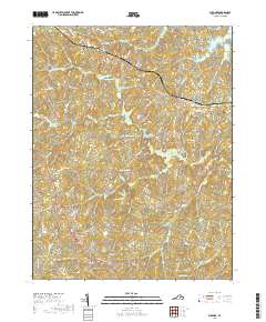
2019 Map of Buckner
USGS Topo · Published 2019About this map
Buckner and the intersection at Gardners Crossroads anchor this survey of rural Louisa County, where the landscape is defined by the winding course of the Little River and its numerous tributaries. The area is marked by a complex network of water bodies, including Swift Millpond, Chisholm Lake, and the southern reaches of Lake Anna near Jerdone Island. This hydrologic pattern suggests a long history of water management and milling in the region, evidenced by the many ponds and creek branches like Horsepen Br and Bong Cr that carve through the local topography.
Find a feature on this map
76 named features on this map. Tap any name to fly to it.
Don’t see what you’re looking for? This feature index may not catch every label — zoom into the map to look around manually.
Map Details
Editions of this 2019 Buckner Map
This is the sole edition of this map. No revisions or reprints were ever made.
Other maps of this area

1887 · Spottsylvania
USGS Topo · 1:125,000

1890 · Goochland
USGS Topo · 1:125,000

1892 · Spottsylvania
USGS Topo · 1:125,000

1892 · Goochland
USGS Topo · 1:125,000

1942 · Mineral
USGS Topo · 1:31,680

1942 · Partlow
USGS Topo · 1:31,680

1942 · Contrary Creek
USGS Topo · 1:31,680

1942 · Pendleton
USGS Topo · 1:24,000

1942 · Buckner
USGS Topo · 1:24,000

1942 · Beaverdam
USGS Topo · 1:24,000