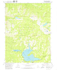
1979 Map of Bucks Lake
USGS Topo · Published 1979About this map
Bucks Lake and its smaller counterpart, Lower Bucks Lake, dominate this high-elevation landscape within the Plumas National Forest. The 1970s terrain is defined by a dense network of alpine lakes and named peaks such as Bucks Mountain and Spanish Pk. Industrial and recreational history intersect at the Shenandoah Mine in the north and the Mormon Trail Camp near the lakeshore. The presence of multiple gaging stations and dams reflects the region's importance for water management, while the Pacific Crest National Scenic Trail winds through the crests, passing by Three Lakes and Silver Lake. The map reveals a land utilized for both resource extraction and backcountry passage, with features like Milk Ranch Creek and Grizzly Creek carving deep drainages through the steep mountainsides.
Find a feature on this map
56 named features on this map. Tap any name to fly to it.
Don’t see what you’re looking for? This feature index may not catch every label — zoom into the map to look around manually.
Map Details
Editions of this 1979 Bucks Lake Map
2 editions found
Other maps of this area

1886 · Lassen Peak
USGS Topo · 1:250,000

1888 · Bidwell Bar
USGS Topo · 1:125,000

1891 · Bidwell Bar
USGS Topo · 1:125,000

1892 · Lassen Peak
USGS Topo · 1:250,000

1893 · Bidwell Bar
USGS Topo · 1:125,000

1894 · Lassen Peak
USGS Topo · 1:250,000

1895 · Bidwell Bar
USGS Topo · 1:125,000

1897 · Bidwell Bar
USGS Topo · 1:125,000

1950 · Bucks Lake
USGS Topo · 1:62,500

1955 · Almanor
USGS Topo · 1:62,500