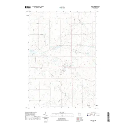
2018 Map of Bucks Lake
USGS Topo · Published 2018About this map
The Ice Age National Scenic Trail winds through this section of Rusk County, marking a glacial landscape defined by numerous kettle lakes and wetland flowages. This 2018 survey reveals a drainage network dominated by the S Fork Hemlock Cr and Big Weirgor Cr, which feed into substantial water bodies like Bucks Lake and the Murphy Flowage. The topography rises toward the south near Mt Atlanta, while the northern reaches are crisscrossed by a grid of rural routes such as Dejung Rd and N Bucks Lake Rd. The presence of Hill Trail Flowage and various smaller basins like Lost Lake and Perch Lake indicates a territory heavily shaped by post-glacial hydrology, preserved here for hikers and conservationists. A network of trails, including Serley Camp Trl and Four Hill Trl, provides access to the dense woodland and waterway systems that characterize this part of northern Wisconsin.
Find a feature on this map
38 named features on this map. Tap any name to fly to it.
Don’t see what you’re looking for? This feature index may not catch every label — zoom into the map to look around manually.
Map Details
Editions of this 2018 Bucks Lake Map
This is the sole edition of this map. No revisions or reprints were ever made.
Other maps of this area

1945 · Meteor
USGS Topo · 1:48,000

1948 · Weyerhauser
USGS Topo · 1:48,000

1949 · Meteor
USGS Topo · 1:48,000

1949 · Rice Lake
USGS Topo · 1:48,000

1950 · Weyerhauser
USGS Topo · 1:48,000

1951 · Rice Lake
USGS Topo · 1:48,000

1951 · Chetek
USGS Topo · 1:62,500

1953 · Rice Lake
USGS Topo · 1:250,000

1959 · Rice Lake
USGS Topo · 1:250,000

1965 · Rice Lake
USGS Topo · 1:62,500