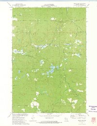
1972 Map of Bucks Lake
USGS Topo · Published 1974About this map
The Blue Hills dominate this portion of Rusk County, creating a landscape defined by glacial topography and an extensive network of managed water bodies. In the early 1970s, this area served as a significant recreational and conservation hub, anchored by the Devils Creek State Wildlife Management Area and the Blue Hills Lookout Tower standing near Mt Atlanta. The map reveals a complex system of flowages and natural lakes, including Murphy Flowage, Audie Lake, and Bucks Lake, many featuring dedicated picnic areas and campgrounds. A local Townhall and scattered gravel pits point to the civic and material needs of the rural townships of Wilson, Wilkinson, Atlanta, and Murry. The presence of the Serley Camp Trail and numerous unnamed trails suggest a region deeply integrated with timber management and seasonal outdoor activity.
Find a feature on this map
39 named features on this map. Tap any name to fly to it.
Don’t see what you’re looking for? This feature index may not catch every label — zoom into the map to look around manually.
Map Details
Editions of this 1972 Bucks Lake Map
This is the sole edition of this map. No revisions or reprints were ever made.
Other maps of this area

1945 · Meteor
USGS Topo · 1:48,000

1948 · Weyerhauser
USGS Topo · 1:48,000

1949 · Meteor
USGS Topo · 1:48,000

1949 · Rice Lake
USGS Topo · 1:48,000

1950 · Weyerhauser
USGS Topo · 1:48,000

1951 · Rice Lake
USGS Topo · 1:48,000

1951 · Chetek
USGS Topo · 1:62,500

1953 · Rice Lake
USGS Topo · 1:250,000

1959 · Rice Lake
USGS Topo · 1:250,000

1965 · Rice Lake
USGS Topo · 1:62,500