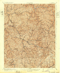
1916 Map of Bucu
USGS Topo · Published 1932About this map
Sandy Ridge forms a massive topographic spine across this southwest Virginia landscape, where the headwaters of the Levisa Fork and its numerous tributaries have carved a dense network of hollows. Surveyed just before the first world war, the map reveals a remote Appalachian community organized around small rural schools like Garden School, Hurricane School, and Cane Creek School. These schoolhouses, often bearing the names of local families or nearby watercourses, served as the primary social anchors for dispersed settlements in Buchanan, Dickenson, and Russell counties. The arrival of industrial infrastructure is evident along the southern edge, where the Norfolk and Western railway traces the terrain near Wilder. Meanwhile, tiny post offices and hamlets such as Bucu, Deskins, and Vansant sit tucked into narrow valleys, connected by mountain gaps like Indian Grave Gap and Abners Gap.
Find a feature on this map
86 named features on this map. Tap any name to fly to it.
Don’t see what you’re looking for? This feature index may not catch every label — zoom into the map to look around manually.
Map Details
Editions of this 1916 Bucu Map
3 editions found

Other maps of this area

1886 · Grundy
USGS Topo · 1:125,000

1890 · Grundy
USGS Topo · 1:125,000

1891 · Tazewell
USGS Topo · 1:125,000

1891 · Abingdon
USGS Topo · 1:125,000

1892 · Grundy
USGS Topo · 1:125,000

1894 · Abingdon
USGS Topo · 1:125,000

1895 · Tazewell
USGS Topo · 1:125,000

1897 · Tazewell
USGS Topo · 1:125,000

1897 · Bristol
USGS Topo · 1:125,000

1902 · Bristol
USGS Topo · 1:125,000