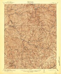
1916 Map of Bucu
USGS Topo · Published 1944About this map
Sandy Ridge and Big A Mtn anchor the high elevations of this Appalachian landscape, where the headwaters of the Russell Fork and Dismal Creek carve a network of steep hollows. Surveyed in 1913-14, the map reveals a remote region transitioning through industrial expansion, specifically via the Dickenson and Russell and Norfolk and Western railroads. These rail lines follow the narrow valley floors to reach timber and mineral outposts like Wilder and Vansant.
Find a feature on this map
75 named features on this map. Tap any name to fly to it.
Don’t see what you’re looking for? This feature index may not catch every label — zoom into the map to look around manually.
Map Details
Editions of this 1916 Bucu Map
3 editions found

Other maps of this area

1886 · Grundy
USGS Topo · 1:125,000

1890 · Grundy
USGS Topo · 1:125,000

1891 · Tazewell
USGS Topo · 1:125,000

1891 · Abingdon
USGS Topo · 1:125,000

1892 · Grundy
USGS Topo · 1:125,000

1894 · Abingdon
USGS Topo · 1:125,000

1895 · Tazewell
USGS Topo · 1:125,000

1897 · Tazewell
USGS Topo · 1:125,000

1897 · Bristol
USGS Topo · 1:125,000

1902 · Bristol
USGS Topo · 1:125,000