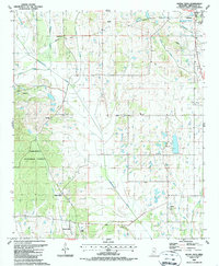
1987 Map of Buena Vista
USGS Topo · Published 1987About this map
Buena Vista and the southern edge of Okolona anchor this landscape during the mid-1980s, where the western reaches of the Tombigbee National Forest meet a network of creek bottoms and rural farmsteads. The terrain is defined by the winding course of Chuquatonchee Creek and its many tributaries, including Mattubby Creek, Jolly Creek, and Bogue Culley. This map provides a detailed view of the rural religious and social fabric of Chickasaw County, documenting numerous local congregations such as Boone Ch, Palestine Ch, and Red Bud Ch. Genealogists will find particular value in the several family-named burial sites and churchyards, including the Pulliam Cem, Snow Cem, and the Jolly Ch Cem. Local industry is represented by the Claypits located north of Buena Vista, suggesting the persistence of small-scale resource extraction in the area.
Find a feature on this map
30 named features on this map. Tap any name to fly to it.
Don’t see what you’re looking for? This feature index may not catch every label — zoom into the map to look around manually.
Map Details
Editions of this 1987 Buena Vista Map
This is the sole edition of this map. No revisions or reprints were ever made.
Other maps of this area

1953 · West Point
USGS Topo · 1:250,000

1956 · Tupelo
USGS Topo · 1:250,000

1958 · Tupelo
USGS Topo · 1:250,000

1958 · West Point
USGS Topo · 1:250,000

1959 · Van Vleet
USGS Topo · 1:62,500

1963 · West Point
USGS Topo · 1:250,000

1965 · Egypt
USGS Topo · 1:24,000

1966 · Shannon
USGS Topo · 1:24,000

1966 · Prairie
USGS Topo · 1:24,000

1966 · Troy SE
USGS Topo · 1:24,000