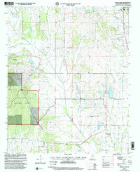
2000 Map of Buena Vista
USGS Topo · Published 2002About this map
Chuquatonchee Creek and its many tributaries, including Cane Creek and Shaw Creek, define the drainage patterns of this Chickasaw County landscape at the turn of the millennium. The settlement of Buena Vista sits in the southern portion of the sheet, while the outskirts of Okolona are visible in the northeast near the Sewage Disposal Pond. This area is characterized by a high density of rural religious and burial sites, which are essential for genealogical research in this part of Mississippi. Significant landmarks include New Hope Ch, Palestine Cem, and the Pulliam Cem. The western edge of the map features the eastern boundary of the Tombigbee National Forest, while industrial activity is noted at the Claypits near the southern border. The intricate network of creek bottoms, such as Red Bud Creek and Jolly Creek, highlights the topographical complexity of the prairie and forest margins.
Find a feature on this map
33 named features on this map. Tap any name to fly to it.
Don’t see what you’re looking for? This feature index may not catch every label — zoom into the map to look around manually.
Map Details
Editions of this 2000 Buena Vista Map
This is the sole edition of this map. No revisions or reprints were ever made.
Other maps of this area

1953 · West Point
USGS Topo · 1:250,000

1956 · Tupelo
USGS Topo · 1:250,000

1958 · Tupelo
USGS Topo · 1:250,000

1958 · West Point
USGS Topo · 1:250,000

1959 · Van Vleet
USGS Topo · 1:62,500

1963 · West Point
USGS Topo · 1:250,000

1965 · Egypt
USGS Topo · 1:24,000

1966 · Shannon
USGS Topo · 1:24,000

1966 · Prairie
USGS Topo · 1:24,000

1966 · Troy SE
USGS Topo · 1:24,000